Module 4: Bathymetry
On March 25, 2012, James Cameron, director of such films as "Avatar" and "Titanic," climbed into a submersible that he helped design to travel to the Challenger Deep, the deepest point in all of the Earth's oceans. Back in 1962, only one manned expedition had ever visited this region, nearly seven miles beneath the surface. That visit only lasted 20 minutes on the ocean floor and the ship stirred up so much sediment during its landing that the divers saw very little. In contrast, Cameron's visit lasted three hours and he was able to collect a number of samples for scientists to analyze. He plans on using this journey's footage and other footage to make a movie showing what the deep sea looks like.
Imagine that you have designed something better than Cameron's submersible - you have designed a suit that enables you to travel to any distance under the ocean, regardless of the depth or pressure. As your first mission, you have decided to be the first person to walk to the middle of the Atlantic Ocean and make a bathymetric map of your findings. Bathymetry (pronounced buh-THI-ma-tree) is the measurement of water depth in oceans and lakes. If you want to know how deep the bottom of the ocean floor is in a certain region, you would consult a bathymetric map.
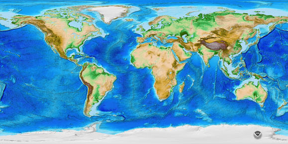
Bathymetric and topographic map of the Earth. The darker blue regions in the oceans are deepest.
What does the bottom of the ocean look like? It may look sandy off of the coast of the Outer Banks in North Carolina, but is it like that 10 miles offshore? You might be surprised to find out that the bottom of the ocean is not just flat soil covered with sand or rocks - there are mountains and volcanoes under the ocean. You may even need to carry some mountaineering gear to climb the steep peaks!
Using bathymetric maps, you are going to look at the different geologic features of the ocean floor, including the continental margin; the mid-ocean ridges and hydrothermal vents; the abyssal plain; seamounts and guyots; and trenches. To take a journey to the bottom of the ocean, you are going to need to know how to read a map and you should plan for what you hope to see. Get going!
Getting Started
![]()
 In this non-graded interactivity, see how much you already know about the bottom of the ocean. Follow the instructions on each questions slide. Click SUBMIT to check your response. Click the player button to begin.
Key Vocabulary
To view the definitions for these key vocabulary terms, visit the course glossary.
| abyssal hill | continental slope | Marshall Seamounts |
| abyssal plain | Emperor Seamounts | mid-ocean ridge |
| active margin | fringing reef | passive margin |
| atoll | guyot | pelagic ooze |
| barrier reef | Hawaiian Islands | radiometric dating |
| bathymetry | hot spot | seamount |
| Challenger Deep | hydrothermal vent (black smoker) | shelf break |
| chemosynthesis | lithosphere | subduction zone |
| continental margin | Loihi | submarine canyon |
| continental rise | magnetometer | trench |
| continental shelf | Marianas Trench | tube worms (riftia pachyptila) |