Physical Geography of South Asia
Physical Features of South Asia

South Asia is located on a large landmass known as the Indian subcontinent. This landmass makes up the southern part of the Asian continent. The region is surrounded by oceans and bordered by steep mountains in the north. In this interactivity, you will explore the physical features of South Asia. Click the player to begin.
View a printable version of this interactivity or an ADA compliant transcript.
Climate Regions
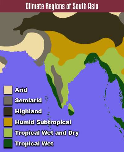
South Asia has a variety of low and middle latitude climate zones. Low latitude tropical climates are located near the ocean. Tropical wet zones span several coastal areas. Specifically, the southwestern coasts of the Indian subcontinent and Sri Lanka have a tropical wet climate. So does the eastern coast of the Bay of Bengal. Farther inland, the climate shifts to tropical wet and dry, and then humid subtropical. Humid subtropical is a warm middle latitude climate that is also found in the southeastern United States.
There are several mountain ranges located in South Asia. The Himalayas and the Hindu Kush span the northern part of the region. These mountains have a highland climate. The temperature, precipitation, and vegetation of a highland climate depend on the altitude. At the highest altitudes, it remains cold all year. Snow and ice cover the highest peaks and there is little vegetation. These massive mountains also create a huge rain shadow to the north. The deserts and dry steppe of Central Asia are located in this rain shadow. The Western Ghats create a smaller rain shadow. This has created a semiarid region on the Deccan plateau. There also arid and semiarid zones in the northwestern part of the region.
Monsoons
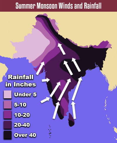
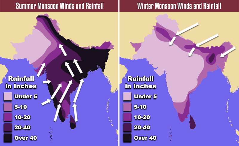
South Asia’s climate is greatly influenced by seasonal winds, called monsoons. In the summer, winds blow northward from the Indian Ocean. These winds contain a lot of moisture. There is heavy rainfall throughout the region because of these wet seasonal winds. The rain fills reservoirs and irrigates crops, but it also causes flooding and landslides.
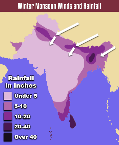
In the winter, winds blow southward from the Himalayas. These winds are drier than the summer monsoons. As a result, winter monsoons bring less rain and are often associated with droughts. Dry air and drought can ruin crops. This can hurt local farmers and parts of the economy.
Natural Hazards in South Asia
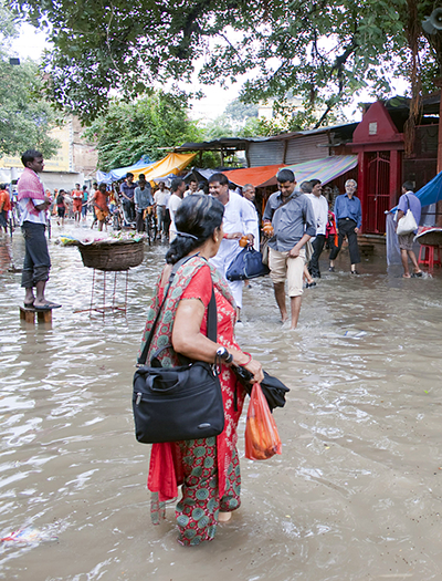
Flooded street in India during the summer monsoon
South Asia has been home to various civilizations throughout history. The region has abundant arable land. Rivers provide access to freshwater. It is also naturally protected by mountains and oceans. However, there are several natural hazards that negatively impact the region. These hazards can be life threatening in that they have the potential to damage infrastructure, ruin crops, and contaminate waterways.
South Asia is susceptible to earthquakes, volcanoes, and tsunamis. This is because South Asia is located on the Indian plate. The Indian plate slowly moves against other tectonic plates, building tension. This tension is periodically released as an earthquake or a volcanic eruption. When an earthquake or eruption occurs underwater, it can create a tsunami. A tsunami is a large ocean wave. These waves can be massive and cause sudden flooding in coastal areas.
Flooding also occurs during wet summer monsoons. The Ganges and Brahmaputra become major flood hazards due to the increased rain. Typhoons bring heavy rain along with strong winds. Climate change has made these tropical storms more intense and more frequent.
Physical Geography of South Asia Review

 Now that you have learned about the major physical regions, landforms, and water features of South Asia, review your knowledge in this interactivity. Click the player to get started.


