Physical Geography of Latin America and the Caribbean
Physical Regions of Latin America and the Caribbean
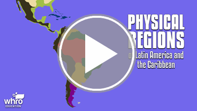
Latin America and the Caribbean have a wide variety of physical features and landscapes. Highland plateaus, volcanic islands, fertile grasslands, arid deserts, and tropical rainforests are all found in this region. In this interactivity, you will explore the major physical regions of Latin America and the Caribbean. Click the player to begin.
View a printable version of this interactivity or an ADA compliant transcript.
Climate Regions
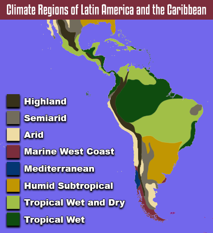
Climate Regions of Latin America and the Caribbean: Detailed Description
The climate of Latin America and the Caribbean is predominately tropical. This is because most of the region lies in the low latitudes, between the Tropic of Cancer and the Tropic of Capricorn. There are tropical wet climate regions, which contain rainforest vegetation. There are also tropical wet and dry climate regions, which contain savanna vegetation. The largest tropical wet region is in South America, near the Equator. This is where the Amazon Rainforest is located. North and south of the rainforest, the climate mostly shifts to tropical wet and dry.
Elevation also has a major impact on the climate of Latin America and the Caribbean. This is because highland climates are found throughout the region. The temperature, precipitation, and vegetation of a highland climate region vary as you travel higher. As a result, highland climate regions can be divided into different zones, or layers, based on elevation. This layering is known as vertical zonation.
Vertical Zonation
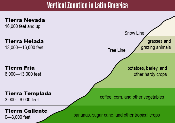
There are five vertical zones in Latin America, each with a Spanish name. The lowest zone is located just above sea level. It is known as tierra caliente, which means hot land. The tierra caliente has a tropical climate that is ideal for growing crops like bananas and sugar cane. Tierra caliente zones are generally found near the coast, where the base of the mountains meets the ocean.
The tierra templada is above the tierra caliente. The name means temperate land. It begins around 3,000 feet. The tierra templada is slightly cooler than the tierra caliente. However, temperatures in the tierra templada remain relatively warm year-round. This zone is best for growing crops like coffee and corn.
The next zone, called the tierra fría, or cold land, begins at roughly 6,000 feet. The temperatures in this zone are slightly cooler than those in the tierra templada. The trees begin to thin out in the tierra fría, and only heartier crops like potatoes and barley are able to grow. This is the highest zone found in Mexico and Central America.
In the Andes Mountains, there are two additional zones found above the tierra fría. The tierra helada, which means frozen land, begins at approximately 13,000 feet. This zone is marked by the tree line of a mountain, as trees are unable to grow at this altitude. The vegetation of the tierra helada mainly consists of small shrubs and grasses, making the zone suitable for grazing animals. The tierra nevada, which means snowy land, is the highest vertical zone. The tierra nevada begins at about 16,000 feet, and is marked by the snow line of a mountain. Glaciers are able to form at this altitude, even in tropical latitudes.
Physical Geography of Latin America and the Caribbean Review
![]() Now that you have learned about the major physical regions, landforms, and water features of Latin America and the Caribbean, review your knowledge in this interactivity. Click the player to get started.
Now that you have learned about the major physical regions, landforms, and water features of Latin America and the Caribbean, review your knowledge in this interactivity. Click the player to get started.