
Virginia Watersheds and the Chesapeake Bay
Virginia Watersheds
 All rivers and streams flow into larger bodies of water and eventually empty into an ocean. A watershed, or drainage basin, is the entire area of land that drains into one specific body of water. Virginia has three major watersheds, meaning that every drop of water that ends up in Virginia's rivers and streams eventually empties into one of three places. In this interactivity, learn about each of the river systems in Virginia and discover the watershed to which each belongs. Click the player button to begin.
View a printable version of the interactivity.
The Chesapeake Bay
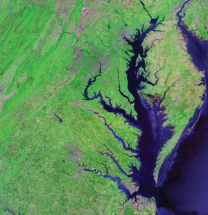 The Chesapeake Bay is a very unique, important body of water. The Chesapeake Bay is an estuary. Estuaries are bodies of water that are open to the ocean. This means fresh water from streams mixes with salt water from the ocean. The Chesapeake Bay is the largest, most productive estuary in the United States. There are over 3,600 species living in the Bay. Many people make a living by collecting resources from the Chesapeake Bay.
The Chesapeake Bay is long, narrow, and shallow with an average depth of 21 feet. The opening to the Atlantic Ocean is only 12 miles wide. There are 5 major rivers that feed fresh water into the Bay: the Susquehanna, the Potomac, the Rappahannock, the James, and the York.
The Chesapeake Bay watershed is surrounded by both developed and agricultural areas. If you include the small streams, there are over 100,000 streams that enter the Chesapeake Bay. The shoreline of the Chesapeake Bay includes wetlands and is over 11,000 miles long. Wetlands are important resources because they provide food and shelter for many species, have plants that act as a natural filter for pollution, and protect inland areas from storm surges and flooding.
The Chesapeake Bay Crater and Saltwater Intrusion
The primary drinking water in Hampton Roads, Virginia is at risk from saltwater intrusion. In Hampton Roads, homeowners and communities rely on wells to provide their drinking water. If the well becomes salty, additional treatment is needed to make the water safe for human consumption. While treatment works for public water systems, it will not work for homeowners with private well systems. Water becomes salty near the coast due to saltwater intrusion. Saltwater intrusion occurs because seawater moves inland. Since seawater has a higher density than freshwater, freshwater sits on top of the seawater. However, if larger amounts of water are pumped out of wells, more seawater intrudes upon freshwater sources.
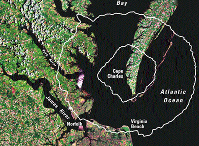
USGS
Chesapeake Bay Impact Crater
Another source of salt water intrusion was discovered by scientists in the early 1980s. As result of high demands on fresh water sources, scientists were drilling and testing different aquifers on the Coastal Plain of Virginia. When drilling a well, scientists take a core sample from each potential well location. The core samples that should have revealed sand, silt, clay, and associated fossils showed something different. There was evidence of rocks that had been heated by the atmosphere, much like a meteorite. Upon further study, scientists discovered a large crater in the Chesapeake Bay that was covered by sediments. Using fossils from the core samples, scientists were able to date the crater at 35 million years old. This means a meteorite crashed into Chesapeake Bay and surrounding areas approximately 35 million years ago. The image of the crater shows the approximate location of the crater created by the meteorite impact. The impact disrupted the aquifers of the region. The present freshwater aquifers now lie directly above a layer of deep saltwater. The only reason the saltwater exists below the freshwater is due to the depression caused by the crater.
Environmental Issues in the Chesapeake Bay
The Chesapeake Bay watershed has an area of 65,000 square miles, and its health is impacted by the influence of 17 million people. With 150 rivers draining into the Chesapeake Bay, six different states affect overall water quality. The most recent reports show that the Chesapeake Bay’s health is declining. The major reason for a low health grade is due to human-created pollution.
 There are two major categories of pollution impacting the Chesapeake Bay. Point source pollution is when pollution originates from one visible point, such as oil leaking from a boat into the water. Non-point source pollution is when there are several sources of pollution that are difficult to specify, such as when fertilizer from nearby farms or lawns is washed into the water by a rainstorm. In this interactivity, learn about the different sources of pollution that are impacting the Chesapeake Bay. Click the player button to begin.
View a printable version of the interactivity.
Deep Dive: Nutrient Pollution
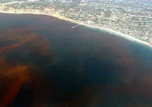 When nutrients enter the water, they increase the amount of plant growth, especially algae growth. This creates what is called an algal bloom or a huge growth in the algae population. Algal blooms often occur during the late spring and summer due to warmer water temperatures. When the algae die, the process of decomposition occurs. This processes uses oxygen. This leaves less oxygen in the water for the fish and plants. During the summer, the Chesapeake Bay has some areas where dissolved oxygen levels in the water sink so low that life cannot survive. These are called dead zones.
![]() To learn more about how fertilizer and agricultural waste can cause nutrient pollution, view the video Chicken Waste and Water Pollution from eMediaVA℠. As you view the video, consider the following questions:
To learn more about how fertilizer and agricultural waste can cause nutrient pollution, view the video Chicken Waste and Water Pollution from eMediaVA℠. As you view the video, consider the following questions:
- Do you think that the agricultural industry should have more pollution regulations?
- How can legislators and farmers work together to prevent the pollution of the Chesapeake Bay?
- What are some of the reasons the scale of chicken farming has changed?
Virginia Watershed and the Chesapeake Bay Review
![]()
 Now that you have explored the Virginia watersheds and the Chesapeake Bay, practice what you have learned. In this non-graded activity, read the directions associated with each question to provide the correct responses. Click the player button to get started.


