


Clouds and Precipitation
Cloud Formation
 You know that air is a mixture of nitrogen and oxygen gases, and that it contains a relatively small amount of water vapor. The amount of water vapor in the air fluctuates as water moves in and out of the atmosphere through the water cycle. Clouds are groups of water drops or ice crystals that form in the atmosphere as warm air rises, expands, and cools. Eventually, the air reaches its dew point, or the temperature at which the water vapor condenses from gas into liquid water or ice. The rate of condensation depends on the atmospheric temperature. These droplets of water form around a condensation nucleus, which is a tiny solid particle in the atmosphere composed of dust, ocean salt, or other particulate matter. When millions of these droplets come together in the atmosphere, clouds form.
Orographic Lifting
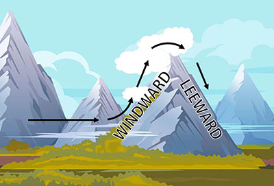 While clouds can form anywhere, air is forced to rise in certain situations. Clouds can form during orographic lifting. Shown in the image to the right, orographic lifting occurs when wind blows air against a mountain and the air is forced upwards. As the air moves up the mountain, it cools, expands, and creates a cloud. Sometimes, large masses of different temperature air meet. When this occurs, air from the warmer mass is forced upwards. This warmer air will rise, expand, and cool forming clouds. Note that the side of the mountain that receives the wind is called the windward side, while the other side is called the leeward side.
Cloud Types
 When you look up at the sky, you might think that there are a lot of different types of clouds. Clouds appear to have different shapes, sizes, and colors. There are only three main types of clouds based on their appearance and altitude. The three main types of clouds are cirrus, stratus, and cumulus. All other clouds are modifications of these three main types. Clouds can exist in three different altitude ranges. View this interactivity to learn about clouds and their classifications. Click the player button to begin.
View a printable version of the interactivity.
The three major types of clouds are shown in the images below. Sometimes, weather prediction is as easy as observing the types of clouds that are in the sky. Of course, viewing the clouds in the sky is not as accurate as a weather forecast predicted by analyzing data. What does each cloud type indicate? Take a moment to review the types of clouds and the associated weather of each.
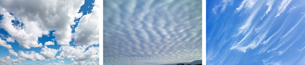
Cumulus, Stratus, and Cirrus Clouds
- Cirrus clouds indicate fair weather in the next twenty-four hours. These clouds can also indicate that a weather change is approaching.
- Cumulus clouds indicate dry, fair conditions. These clouds will grow very tall. If they get too tall they could develop into a cumulonimbus cloud. Cumulonimbus clouds will bring thunderstorms, rain, and possible severe weather.
- The layered stratus clouds will cover the entire sky. This thick blanket of gray clouds indicates overcast skies. These clouds are not known to produce heavy rain or snow. If anything, light snow or drizzle is possible.
![]() If you have ever stepped out of your door on a cool, humid morning, you may have seen fog on the streets where you live. Like clouds, fog occurs when water vapor droplets or ice crystals clump with condensation nuclei amidst cooling temperatures. Unlike clouds, fog occurs very close to the surface of the Earth. Take a few moments to view the video Science of Fog from eMediaVA℠ to see how fog occurs and how it impacts life in San Francisco.
If you have ever stepped out of your door on a cool, humid morning, you may have seen fog on the streets where you live. Like clouds, fog occurs when water vapor droplets or ice crystals clump with condensation nuclei amidst cooling temperatures. Unlike clouds, fog occurs very close to the surface of the Earth. Take a few moments to view the video Science of Fog from eMediaVA℠ to see how fog occurs and how it impacts life in San Francisco.
Precipitation
 Any moisture that falls from clouds in the atmosphere is precipitation. Precipitation can vary in amount, force, and state of matter. The varying amounts of precipitation depends on the atmospheric temperatures, weather conditions, and the amount of water vapor in the air. Most precipitation in the atmosphere begins as a solid form such as snow or ice. As the solid precipitation travels through the atmosphere, it will warm and melt. In this interactivity, learn about the different types of precipitation. Click the player button to begin.
View a printable version of the interactivity
Clouds and Precipitation Review
![]()
 Now that you have investigated clouds and precipitation, practice what you have learned. In this non-graded interactivity, drag the descriptions on the right and drop them next to the terms on the left. Click the player button to begin.