


Weather and Climate
Weather vs. Climate
 Take a look out of the nearest window. How would you describe the current conditions outside? It might be sunny, cool, raining, or cloudy. When you look at the current conditions outside, you are observing weather. Weather refers to the current conditions in the atmosphere, including things like temperature, cloud cover, wind, and precipitation. Weather changes frequently, and sometimes, very quickly.
Climate, on the other hand, refers to the long-term weather conditions in a region. Climate does include factors such as precipitation and temperature, but the focus is on long-term averages over decades, or even longer, rather than the day-to-day variations. There is evidence that Earth’s climate naturally fluctuates between warming periods and cooling periods, including several ice ages. There is also evidence that the climate is currently warming more than the expected natural cycle due to human impacts on the Earth’s atmosphere, specifically the burning of fossil fuels.
Factors That Affect Climate
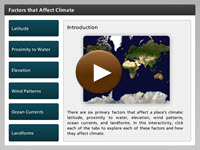 Why do different places have different climates? What can cause them do have different combinations of temperature and precipitation? Why do some places have hot summers yet cold, snowy winters? There are six primary factors that affect a place’s climate: latitude, proximity to water, elevation, wind patterns, ocean currents, and landforms. In the interactivity, learn more about the factors that affect climate. Click the player button to begin.
View a printable version of the interactivity.
Climate Zones
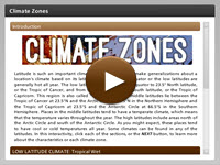 Latitude, proximity to water, elevation, wind, ocean currents, and landforms are all factors that determine a locations climate, but it is latitude that is the most important factor. In this interactivity, explore the climate regions of the low latitudes, middle latitudes, and high latitudes, along with some other climate types. Click the player button to begin.
View a printable version of the interactivity.
Climate Graphs
An easy way to visualize a place’s climate is by using a climate graph. A climate graph is a simple line graph showing a place’s average monthly temperature superimposed over a bar graph showing a place’s average monthly precipitation. The months of the year are placed on the x-axis, while the temperature (in °F or °C) and precipitation (in millimeters or inches) are placed on two y-axes. You can learn a lot about a place’s climate by examining its climate graph. For example, in the climate graph shown below for Edinburgh in Scotland, you can see that that location experiences mild temperatures and evenly distributed rainfall throughout the year.
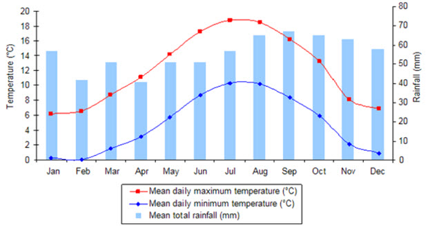
Climate Graph for Edinburgh, Scotland
Global Winds
Courtesy of NASA
Global Circulation of the Earth's Atmosphere
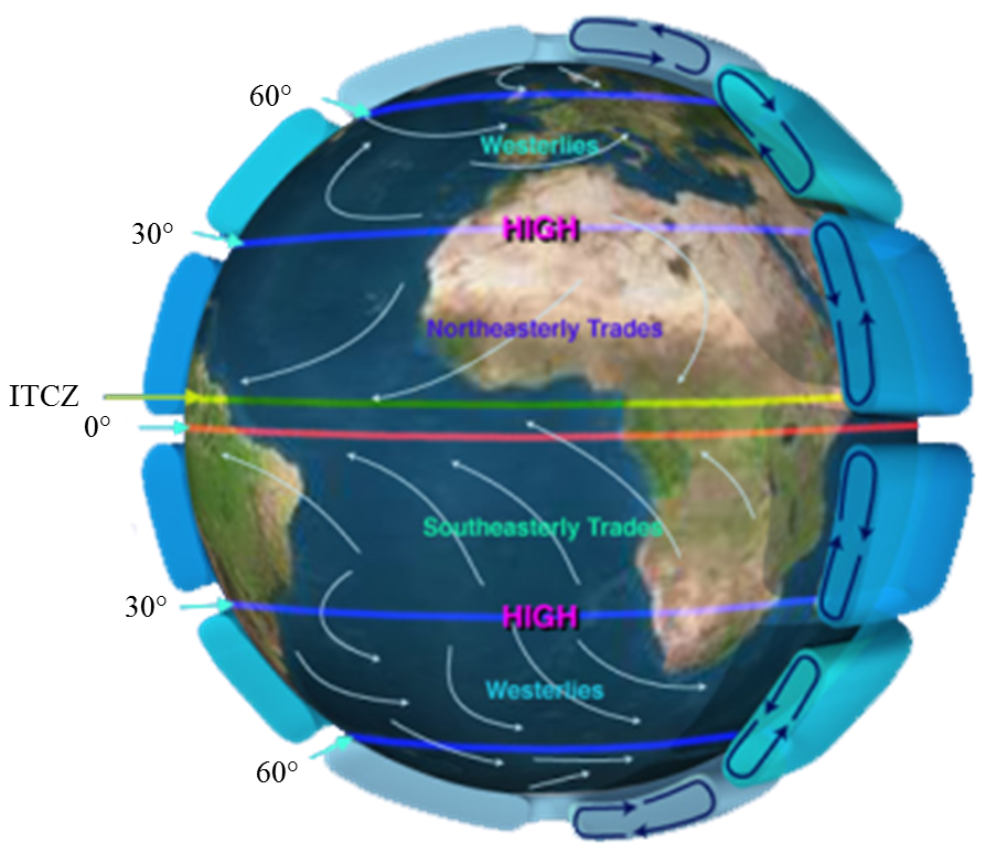
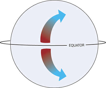
To build a better understanding of climate and natural climatic variations, you need to understand global wind currents. The unequal heating and rotation of the Earth creates three large wind systems in each hemisphere that work together to redistribute heat around the entire Earth. Along the equator, solar radiation is the highest and heat builds up in the atmosphere, creating a large low-pressure band called the Intertropical Convergence Zone or ITCZ. Directly above and below the equator up to 30° North and South latitude are the northeast and southeast Trade Winds. These winds move the warm tropical air towards higher latitudes. The Westerly winds are located from 30° to 60° degrees. These winds move air from west to east. The Polar Easterlies are located between 60° to 90° degrees North and South latitude. Take a moment to view the image and locate each of the global winds.
It is important to remember that these global wind cells are powered by natural convection currents. The warm, moist air in the atmosphere rises, while the cool, dry air sinks. These global convection currents redistribute heat from the equator towards the poles, creating the various global climate zones.
The Coriolis Effect
Courtesy of NOAA Ocean Service Education
The Coriolis Effect
When you look at a diagram of the global wind patterns of the world, you might have noticed that the wind patterns shift towards the right in the Northern Hemisphere and to the left in the Southern Hemisphere. Since the Earth is constantly rotating on its axis, air does not travel in a straight direction, but shifts slightly. This is called the Coriolis effect.
To understand the Coriolis effect, imagine an airplane traveling from the North Pole towards a location near the equator. If the airplane took a straight path its destination, the plane would end up in the wrong location. The Earth rotates 15 degrees each hour. While the plane is flying, the destination is actually moving away from the plane. If the plane travels in a curved path, it will reach its destination because the path of the flight accounts for the amount of rotation.
Jet Streams
![]() Between each of the global wind zones, the stark differences between pressure and temperature create another type of wind. Jet streams are bands of strong westerly winds high in the atmosphere, near the tropopause. The polar jet streams separate the Polar Easterlies from the Prevailing Westerlies. The subtropical jet streams separate the Trade Winds from the Prevailing Westerlies. All jet streams travel between 120 and 240 kilometers per hour. Take a moment to view the video clip below from NASA's Scientific Visualization Studio to observe how the jet streams move over the Northern Hemisphere.
Between each of the global wind zones, the stark differences between pressure and temperature create another type of wind. Jet streams are bands of strong westerly winds high in the atmosphere, near the tropopause. The polar jet streams separate the Polar Easterlies from the Prevailing Westerlies. The subtropical jet streams separate the Trade Winds from the Prevailing Westerlies. All jet streams travel between 120 and 240 kilometers per hour. Take a moment to view the video clip below from NASA's Scientific Visualization Studio to observe how the jet streams move over the Northern Hemisphere.
Air Masses and Fronts
 The global wind belts are mainly associated with regulating Earth's climates, but they do have some influence on weather conditions. However, it is smaller scale air masses that have a more immediate effect on weather conditions. An air mass is a large body of air that forms with specific characteristics such as moisture content and temperature. These characteristics are influenced by where the air mass first forms. Air masses can stay in one general area for up to several days at a time, but as air masses begin to move and change, weather is directly affected.
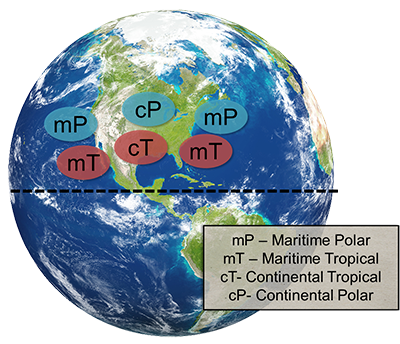
Air masses are influenced by where they form. Air masses that form over land, called continental air masses, are dry, while air masses that form over the ocean, called maritime air masses, can carry large amounts of moisture. Air masses form in different climate regions as well, leading to different air mass temperatures. Air masses are distinguished as polar, tropical, or arctic. The United States experiences several combinations of air masses as you can see from the image. The interactions of these air masses are responsible for the day-to-day weather conditions that you experience.
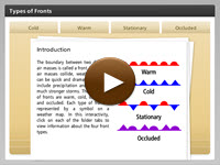 The boundary between two different air masses is called a front. When two air masses collide, weather changes can be quick and dramatic and often include precipitation and sometimes much stronger storms. The four types of fronts are warm, cold, stationary, and occluded. Each type of front is represented by a symbol on a weather map. In this interactivity, click on each of the folder tabs to view information about the four front types.
View a printable version of the interactivity.
Air Pressure
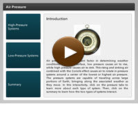 Air pressure is an important factor in determining weather conditions. At Earth’s surface, low pressure causes air to rise, while high pressure causes air to sink. This rising and sinking air combined with the Coriolis effect causes air to rotate in pressure systems around a center of the lowest or highest air pressure. The pressure systems are capable of traveling across large portions of Earth, bringing along the associated weather as they move. In this interactivity, click on the pressure tabs to learn more about each type of system. Then, click on the summary to learn how the two types of systems interact.
View a printable version of the interactivity.
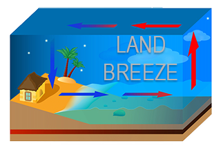
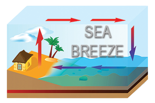
Breezes
Smaller-scale air movement can also occur locally. Areas on the coastline experience both sea breezes and land breezes. Differences in heat capacity of water and land cause convection cells to form. These convection cells move air towards the land during the day and away from the land at night. Roll your cursor over the images below to learn more about land breezes and sea breezes.
View a printable version of the interactivity.
Weather and Climate Review
![]()
 Now that you have explored weather and climate, practice what you have learned. In this non-graded activity, read each question and select the correct response. Click the player button to get started.