


Topographic Maps
 Topographic maps can serve a variety of purposes, from military use to planning infrastructure and finding natural resources. Topographic maps are much different from many of the maps you have studied. View this presentation to become more comfortable reading and analyzing these maps filled with contour lines. Click the player button to begin.
View a printable version of the interactivity.
Visualizing Topography
![]() Topographic maps take three dimensional objects and place them on a two dimension map using contour lines. Can you visualize what a hill, valley, or cliff will look like on topographic map? Being able to identify these objects will help you analyze these maps, especially if you were hiking through rough terrain.
Topographic maps take three dimensional objects and place them on a two dimension map using contour lines. Can you visualize what a hill, valley, or cliff will look like on topographic map? Being able to identify these objects will help you analyze these maps, especially if you were hiking through rough terrain.
To practice visualizing features on a topographic map visit Visualizing Topography from eMediaVA℠. Read the brief introduction and experiment with the on screen settings as you become more familiar with hills, valleys, and cliffs on a topographic map.
Topographic Map Scale
Take a look at the three topographic maps in the images below. All three maps are of the same area: Mount Rainer, a massive volcano located in Washington State. Do you notice any differences in the three topographic maps of the same area? Hopefully you said that they are all a different scale. The United States Geologic Survey (USGS) generally uses three common scales for topographic maps. The detail changes a lot when you change the scale of the map. Hover your mouse over each image to find out more information about the three scales commonly used by the USGS.
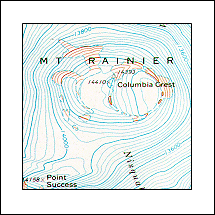
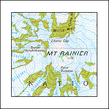
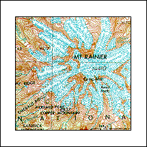
Photo Credit: United States Geological Survey
View a printable version of the interactivity.
Reading Topographic Maps Review
![]()
 Now that you have explored topographic maps, practice what you have learned. In this non-graded interactivity, read each question and then select the appropriate answer. Click the player button to get started.