


Seamounts and Guyots
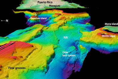
Bathymetric map of Mona Passage off Western Puerto Rico
![]() Bathymetric mapping of the ocean floor is not just an academic exercise. Knowing the location of underwater mountain ranges, seamounts, and guyots is crucial to the safety of ships, among other things.
Bathymetric mapping of the ocean floor is not just an academic exercise. Knowing the location of underwater mountain ranges, seamounts, and guyots is crucial to the safety of ships, among other things.
What other governmental agencies, companies, or organizations would be interested in the mapping of these structures? Make a list of these groups for which you think it would be crucial to chart the seamounts and guyots of the world's oceans